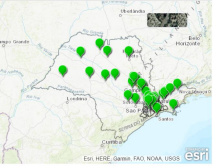
Figure 1. Location of CETESB air quality sensors in the state of São Paulo. Map without scale. Source: CESTESB, 2023.
This research proposes mapping transport flows and emissions on the main highways in the Campinas Metropolitan Region (São Paulo, Brazil) using low-cost sensors (NOTS). These sensors map atmospheric emissions of greenhouse gases (GHGs) and toxic air pollutants (APs) related mainly to traffic emissions. The NOTS were developed by Prof. Dr. Pedro José Perez Martinez in partnership with the University of São Paulo (Brazil) and the University of Surrey (UK). This data collection method will be associated with socio-economic and traffic data and will be aligned with the main policies of the Integrated Urban Development Plan (PDUI) for the Campinas region. In this way, it will be possible to present a temporal and spatial analysis of sustainability indicators with the aim of contributing to regional urban mobility planning and the development of transport-related mitigation policies.
Keywords: transport emissions, low-cost sensors, spatial and temporal mapping.

Room 3
Janini Oliveira Dias da Silva (UNICAMP – Brazil)